
What is the origin of “Dodon” soils?
If you take a tour with a winemaker, the topic will frequently turn to soil. Depending on where you are, you might hear about the kimmeridgian limestone of Chablis, the montmorillonite (aka blue) clay of Pomerol, or the alluvial gravel, clay, and sand of the Rutherford Bench. In many winemakers’ minds, the soil defines the wine, trumping both climate and human influences. To hear a winemaker tell it, the soil of their region or vineyard is unlike the soil anywhere in the world, and without doubt the very best for growing wine grapes. I’m as guilty as anybody of this hyperbole, and to support my case, or perhaps to atone for boastfulness, I set out to understand the origin and implications of the soil at Dodon.

Geologist Bubba Beasley profiles Dodon soils before planting Block 40 in 2015.
Most of what follows traces the geological history of Dodon soils. If you just want the bottom line, you can skip to the last section, Viticulture and Carbon. If you want to learn more, you can listen to Levi Dalton’s excellent interview with geologist Brenna Quigley.
In the Beginning
Much of what farmers think of as soil, something that will support a plant root, is filled with air and water that is constantly exchanged with the atmosphere. Another large portion is composed of living organisms – roots, microbes, arthropods, earthworms, and small mammals – and other organic matter that come and go with the seasons. The solid bits of soil – rocks and minerals - are the most stable and have complex origins that go back about 14.5 billion years to the origin of the universe.
The earliest subatomic particles that make up soil minerals – electrons and quarks – appeared a fraction of a second after the Big Bang. These particles in turn created the protons and neutrons that combined to form hydrogen and helium. Over the next half billion years, these elements joined to produce stars, within which arose the first twenty-six elements of the periodic table, including carbon, oxygen, magnesium, silicon, sulfur, iron, and so on.
Under the right conditions, especially in the cooling aftermath of supernova, the remaining elements appeared, and minerals formed by combining elements into crystals. Because they have gravity, minerals organized into new stars, nebula, planets, and galaxies.
The earth itself formed 4.5 billion years ago out of the debris of exploding stars, so all the mineral components of soil can be said to have cosmic origins. What we see now is merely the result of chemistry, biology, and plate tectonics that recycle the elements over unimaginably long time frames.
It’s a spellbinding story vividly told by George Mason University Professor Robert Hazen in The Story of Earth.
Moving Continents, Building Mountains
The story of Dodon soils starts about a billion years ago with formation of the supercontinent Rodinia. The eastern margins of Laurentia (the geological ancestor of North America) collided with continents that now make up the Baltics and Eastern Europe (called Baltica), the Amazon, and West Africa. When continents collide, the earth’s crust tends to uplift to form tall mountains, a process known as an orogeny. In the case of the eastern portions of Laurentia, the event is known as the Grenville orogeny.
In the 400 million years of Rodinia’s life, weathering and erosion flattened the Grenville mountains, leaving only their innermost cores of metamorphic rock, the type of rock that is created when minerals are subjected to intense pressure. While most of the Grenville rocks remaining today are covered by much newer formations, exposures of these billion year old rocks are found where newer ones have been worn away, including areas north of Interstate 95 in parts of Montgomery, Howard, Carroll, and Baltimore counties, as well as other states throughout the mid-Atlantic and northeast. Much of the Blue Ridge Mountain range of central Virginia has its origins in the Grenville orogeny.
When the tectonic plates reversed direction, Rodinia separated into two large landmasses, Laurentia and Gondwana (the forerunner of Africa, India, South America, Antarctica, and much of southern Asia), and several smaller islands, including Baltica. During this period, Laurentia straddled the equator, with the current east coast facing south. At least one analysis suggests that the land mass on which Dodon now resides was part of Gondwana, located about where the Canary Islands are today.
Oceans Emerge
The rift that split Rodinia began with basaltic lava flows that lasted several hundred million years, creating the Iapetan ocean. Sediments from the eroding Grenville mountain range accumulated along the shoreline, and toward the end of this period, shells from rapidly emerging mollusk populations added carbonates such as calcite to a mix that would eventually be transported to the mid-Atlantic coastal plain that makes up the area east of Interstate 95.
The Taconic Orogeny
The second chapter of Dodon soils begins about 540 million years ago when the continental drifts again changed direction. As Laurentia, Baltica, and a microcontinent known as Avalonia began to drift toward one another, the denser ocean crust was forced under Baltica’s lighter continental crust, creating a zone of subduction, an area much like the current Ring of Fire in the Pacific. The resulting volcanoes and uplift of coastal Baltica, known as the Taconic Orogeny, were separated from Laurentia by a shallow sea basin that contained Grenville sediments and carbonates.
Pangea
The third phase, the Acadian and Alleghenian orogeny, began about 300 million years ago when Laurentia, Baltica, and Gondwana collided to form the supercontinent Pangea, forming the Central Pangean Mountains that eventually became what are now the Appalachian Mountains, Morocco’s Little Atlas Mountains, and the Scottish Highlands. Because it involved two continental plates, this event involved uplift with rock forming by metamorphosis as one continent rolled, like an ocean wave, over the other. The result is layers of diverse rock with a beautiful rolling form, called a syncline, that can be seen at the Sideling Hill road cut on Interstate 68.

Polly and Tom inside the mid-Atlantic rift in Iceland’s Þingvellir National Park
Pangea lasted for about 100 million years, but the direction of plate movement shifted over time. Seven continents began to drift apart to create the earth form that is familiar to us today, leaving Dodon in North America. The breakup of Pangea continues today with lava flows from the Mid-Atlantic Ridge, a rift in the earth’s surface that can be seen in Iceland’s Þingvellir National Park. As a result, the Atlantic Ocean widens by an inch or two each year.
Erosion and Sedimentation
The next 175 million years of the story of Dodon soil is one of erosion and sedimentation. As the continents separated, unconsolidated and partially consolidated sediments deposited along a coastline that is not significantly different from that which exists today. These coastal plain sediments in cross section look like a wedge, thick to the east and thinning to a feather edge at the “fall line” that demarcates a region of hard crystalline basement rock from one with softer, sedimentary and transported rock. Interstate 95 follows the Atlantic seaboard fall line, connecting major cities that mark the end of navigable rivers.
Dramatic Heating and Cooling
The period known as the Mid Miocene Climatic Optimum (MMCO), from 17 to 14 million years ago, was characterized by rising carbon dioxide levels, going from 400 to 500 ppm, and higher temperatures, as much as 22 degrees above those of the preceding 10 million years. The proximal cause of the rising carbon dioxide is believed to be significant tectonic (formation of the Himalayas) and volcanic (formation of the Cascade Mountain range and the subsequent the Columbia River basalt lava flows) activity.
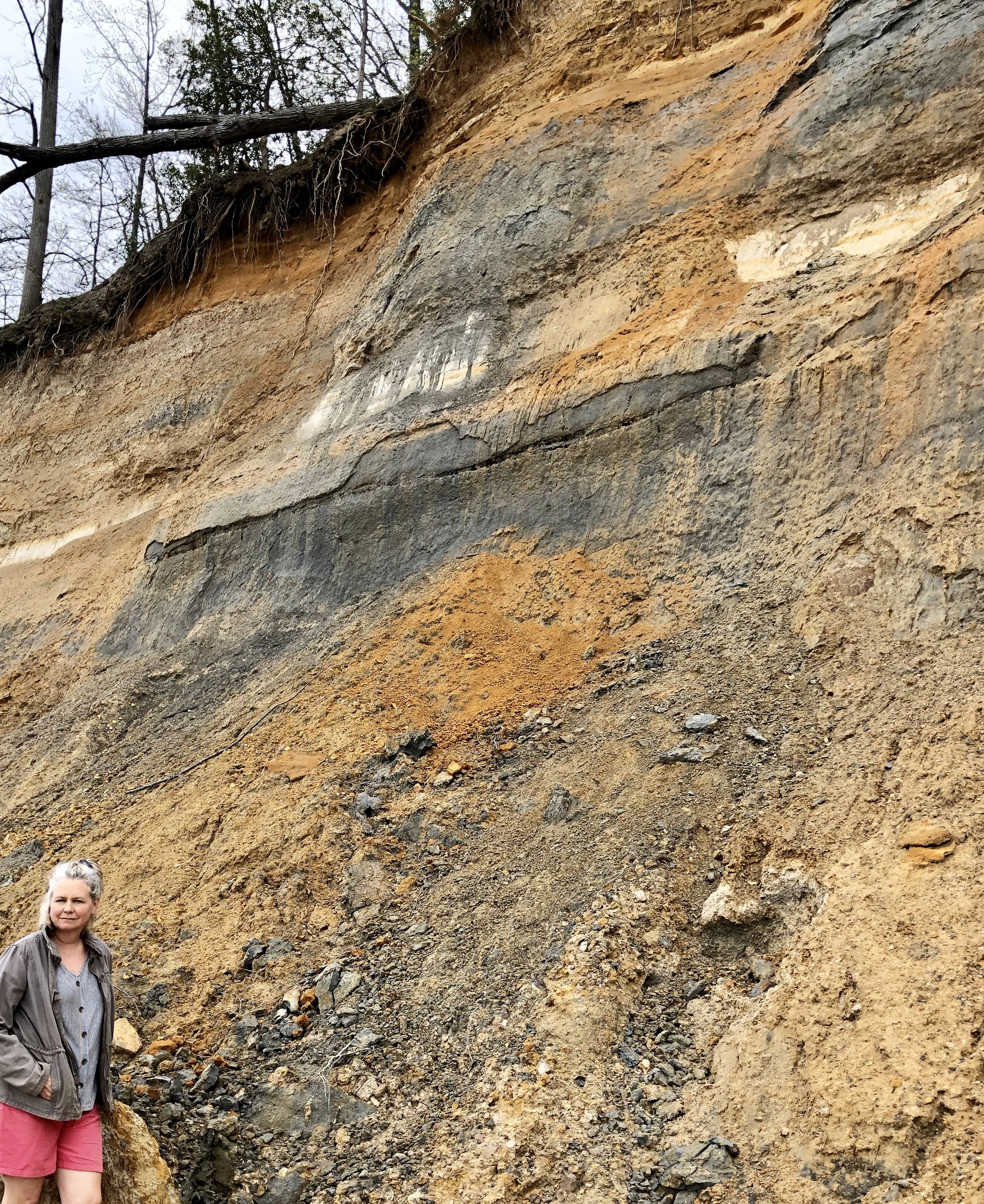
Calvert Cliffs State Park is a good place to see the soil strata left by the third marine transgression during the mid-Miocene. The gray (clay) layers contain a great deal of shell and fossil sediments that may contribute minerality to Dodon wine.
Following the MMCO, the earth dramatically cooled over about 10 million years. Warm season grasses (for example, sorghum and corn) that assimilate carbon dioxide and water more efficiently than cool season grasses (rye and fescue) expanded to become ecologically significant near the end of this period. The resulting high soil organic matter content and water retention capacity of grassland soils that characterized the late Miocene produced a carbon and water vapor sink that, combined with the lower evapotranspiration of grassland, contributed to lower carbon dioxide levels and the cooler, drier climate that has characterized human history.
Sea levels were unusually dynamic during the MMCO and the cooling period that followed. Along the Atlantic seaboard, three marine transgression and regression events left distinct sedimentary strata characterized by coarse-grained rock and mineral fragments such as sandstone, deposited during periods of rapidly moving water, and fine-grained silts or marls (a combination of limestone sediments and silt) deposited in slower moving, estuary environments. Fossilized remains of sea life add to the complexity of these sedimentary soils. The Calvert Formation, which makes up the exposed soil of a large portion of southern Maryland, including Dodon, was deposited during the last of these events.
As the climate cooled, the oceans receded, leaving a final layer of shells and other sea deposits. Additional soils were transported from the west by wind, erosion, and rivers. These soils are the result of weathering mountains that had been compressed, folded, rolled, and telescoped so that most of the rocks moved great distances from their site of origin and were then stacked like a shuffled deck of cards over hundreds of millions of years. Fine, silty particles from weathering of these diverse rocks arrived by wind and slow moving delta waters. Larger particles and gravel arrived by faster moving river flows.
Animals and Agriculture
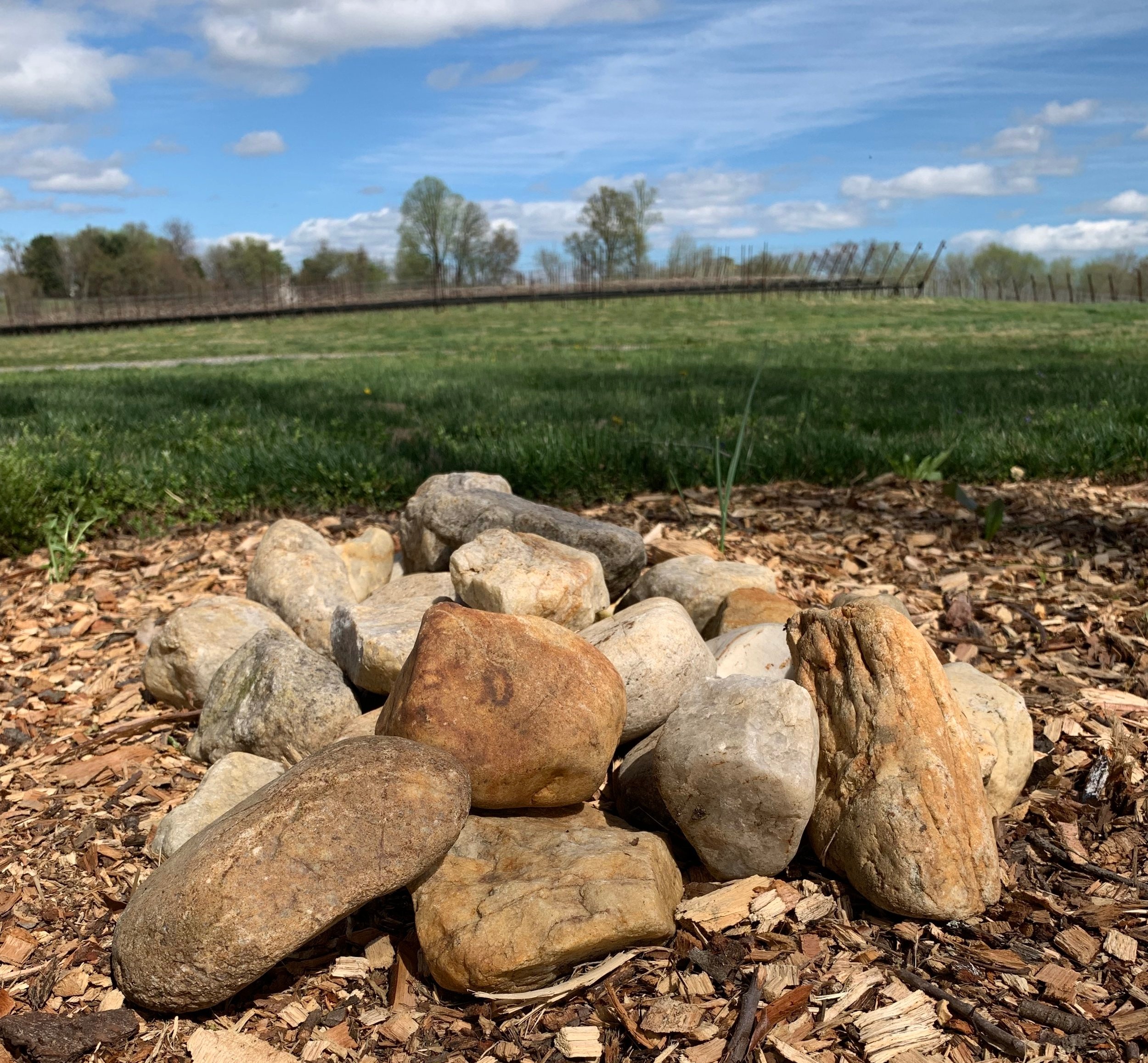
Rocks from diverse origins transported during the Pleistocene to Dodon by nature.
The earth continued to cool until the Pleistocene, about 3.5 million years ago, when carbon dioxide levels stabilized into an oscillating pattern, ranging from about 150 ppm to 275 ppm that persisted until about 1950. This period has been dominated by repeated glaciation (at the lower bounds of atmospheric carbon dioxide) that reached the 40th parallel, about the Mason-Dixon line, with permafrost likely covering most of southern Maryland. While in some areas there is a thin layer of soil transported largely by wind, most of the exposed soil at Dodon is characterized by erosion-prone Calvert sand and clay deposited during the Miocene. In a few areas, including the outcrop in the Cabernet Sauvignon blocks of Dodon’s east vineyard, there is a sheet of erosion resistant sand and gravel deposited by a river during the Pleistocene, about 2.5 million years ago.
Viticulture and Carbon
Although the parent material has been reasonably constant since the Miocene, soil, even its mineral component, is constantly changing as a result of the biological and physical forces around it. Trees and grasses sequester carbon and add organic matter. Bacteria, fungi, and protozoa secrete enzymes that change soil chemistry, erode rocks into minerals, and release carbon into the atmosphere. Wind and rain add to this weathering, and they transport minerals into streams where they wash or blow into the Chesapeake Bay. Humans also modify the soil, starting with Native Americans who burned the underbrush of the native forests to facilitate hunting. Later European settlers cut down trees, built houses and roads, and cultivated crops, adding another powerful force for change.
What can we learn from the story of Dodon soils? The first lesson is that soil is not a static object. Rather it is in constant flux, so there is no single origin for the soil here. That said, several themes relevant to viticulture at Dodon emerge from the history.
Until European settlers arrived in North America, our region was largely forest, suggesting that the soil (and climate) here may provide better habitat for trees than grassland. We believe that this soil will also be good for grapevines, which grow naturally in forested environments. Viewed from this perspective, a vineyard that mimics a forest is likely to be healthier and more resilient than one that resembles pasture. Because they are replenished by woody material - fallen trees and leaf litter, forest topsoils differ significantly in their organic and microbial content from grassland. I’ll have more on the implications of this conclusion in a subsequent post.
The complex nature of the soil at Dodon provides an interesting context in which to grow grapes. Flavors in wine are in part derived from minerals in soil, which as we’ve seen vary considerably based on the source of the parent material and subsequent environmental influences. These minerals create the environment in which the mycorrhiza (fungi that live in symbiotic ways with vine roots) breakdown nutrients and supply them to the vine. At Dodon, because the parent material comes from extremely heterogeneous origins that in some cases formed more than a billion years ago, flavors of wine grown here are likely to differ from regions with more homogeneous mineral components.
A final lesson may be crucial to our collective future, not just our young vineyard. Although the cause of rising carbon dioxide levels is different, the middle and late Miocene were, like our own time, characterized by rising temperature, melting glaciers, and encroaching seas. The subsequent cooling climate was partly, if not mostly, the result of carbon sequestration in rangelands and mineralization into carbonates in deep oceans, technologies that are available to us today as we search for solutions to climate change.